First Nations and Treaty Areas in Manitoba
PDF Version (1.63 Mb, 1 page)
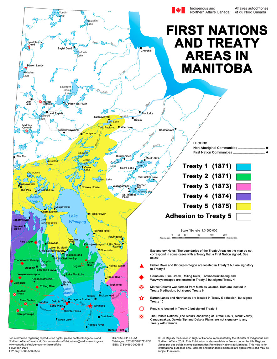
Text description of the Map of First Nations and Treaty Areas in Manitoba
This map of Manitoba shows the approximate locations of the 63 First Nations located throughout the province and the boundaries of the numbered Treaties in Manitoba. All treaty boundaries are approximate.
The boundaries of the Treaty Areas on the map do not correspond in some cases with a Treaty that a First Nation signed. Fisher River is located in Treaty 2 but is signatory to Treaty 5. Gamblers, Rolling River and Waywayseecappo are located in Treaty 2, but signed Treaty 4. Kinonjeoshtegon is located in Treaty 2, but signed Treaty 5. Marcel Colomb was formed from Mathias Colomb. Both are located in Treaty 5 adhesion, but signed Treaty 6. Barren Lands and Northlands are located in Treaty 5 adhesion, but signed Treaty 10. Peguis is located in Treaty 2, but signed Treaty 1. The Dakota Nations (The Sioux), consisting of Birdtail Sioux, Sioux Valley, Canupawakpa, Dakota Tipi and Dakota Plains are not signatory to any Treaty with Canada
Treaty 1
Beginning at the international boundary line near its junction with the Lake of the Woods, at a point due north from the centre of Roseau Lake; thence to run due north to the centre of Roseau Lake; thence northward to the centre of White Mouth Lake, otherwise called White Mud Lake; thence by the middle of the lake and the middle of the river issuing therefrom to the mouth thereof in Winnipeg River; thence by the Winnipeg River to its mouth; thence westwardly, including all the islands near the south end of the lake, across the lake to the mouth of Drunken River; thence westwardly to a point on Lake Manitoba half way between Oak Point and the mouth of Swan Creek; thence across Lake Manitoba in a line due west to its western shore; thence in a straight line to the crossing of the rapids on the Assiniboine; thence due south to the international boundary line; and thence eastwardly by the said line to the place of beginning.
The following First Nations are Treaty 1:
- The Brokenhead Ojibway First Nation is located 64 kilometres north of Winnipeg.
- Fort Alexander First Nation (Sagkeeng) is situated 122 kilometres northeast of Winnipeg.
- Long Plain First Nation is located 14 kilometres southwest of Portage la Prairie along the Assiniboine River and 98 kilometres west of Winnipeg.
- Peguis First Nation is located 170 kilometres north of Winnipeg.
- Roseau River Anishinabe First Nation is located 92 kilometres south of Winnipeg, and is about 20 kilometres north of the Canada/United States border. e.
- Sandy Bay First Nation is situated on the west shore of Lake Manitoba about 165 kilometres northwest of Winnipeg.
- Swan Lake First Nation is located approximately 135 kilometres southeast of Brandon and 175 kilometres southwest of Winnipeg.
Treaty 2
Beginning at the mouth of Winnipeg River, on the north line of the lands ceded by said treaty; thence running along the eastern shore of Lake Winnipeg northwardly as far as the mouth of Beren's River; thence across said lake to its western shore, at the north bank of the mouth of the Little Saskatchewan or Dauphin River; thence up said stream and along the northern and western shores thereof, and of St. Martin's Lake, and along the north bank of the stream flowing into St. Martin's Lake from Lake Manitoba by the general course of such stream to such last-mentioned lake; thence by the eastern and northern shores of Lake Manitoba to the mouth of the Waterhen River; thence by the eastern and northern shores of said river up stream to the northernmost extremity of a small lake known as Waterhen Lake; thence in a line due west to and across lake Winnepegosis; thence in a straight line to the most northerly waters forming the source of the Shell River; thence to a point west of the same two miles distant from the river, measuring at right angles thereto; thence by a line parallel with the Shell River to its mouth, and thence crossing the Assiniboine River and running parallel thereto and two miles distant therefrom, and to the westward thereof, to a point opposite Fort Ellice; thence in a south-westwardly course to the north-western point of the Moose Mountains; thence by a line due south to the United States frontier; thence by the frontier eastwardly to the westward line of said tract ceded by treaty as aforesaid; thence bounded thereby by the west, northwest and north lines of said tract, to the place of beginning, at the mouth of Winnipeg River.
The following First Nations are Treaty 2:
- Dauphin River First Nation is located 240 kilometres north of Winnipeg.
- The Ebb and Flow First Nation is located 83 kilometres east of Dauphin, on the west shore of Ebb and Flow Lake, and approximately 262 kilometres north of Winnipeg.
- Keeseekoowenin First Nation is located 278 kilometres northwest of Winnipeg.
- Lake Manitoba First Nation is located along the northeast shore of the lower basin of Lake Manitoba, approximately 170 kilometres northwest of Winnipeg.
- Lake St. Martin First Nation is located 255 kilometres northwest of Winnipeg.
- Little Saskatchewan First Nation is situated 255 kilometres north of Winnipeg on the western shore of Lake St. Martin.
- O-Chi-Chak-Ko-Sipi First Nation is located on Lake Manitoba, 364 kilometres northwest of Winnipeg.
- Pinaymootang First Nation is situated on Lake St. Martin, 240 kilometres northwest of Winnipeg.
- Skownan First Nation is located on the southwest shore of Waterhen Lake, approximately 280 kilometres north of Winnipeg.
Treaty 3
Commencing at a point on the Pigeon River route where the international boundary line between the Territories of Great Britain and the United States intersects the height of land separating the waters running to Lake Superior from those flowing to Lake Winnipeg; thence northerly, westerly and easterly along the height of land aforesaid, following its sinuosities, whatever their course may be, to the point at which the said height of land meets the summit of the watershed from which the streams flow to Lake Nepigon; thence northerly and westerly, or whatever may be its course, along the ridge separating the waters of the Nepigon and the Winnipeg to the height of land dividing the waters of the Albany and the Winnipeg; thence westerly and north-westerly along the height of land dividing the waters flowing to Hudson's Bay by the Albany or other rivers from those running to English River and the Winnipeg to a point on the said height of land bearing north forty-five degrees east from Fort Alexander, at the mouth of the Winnipeg; thence south forty-five degrees west to Fort Alexander, at the mouth of the Winnipeg; thence southerly along the eastern bank of the Winnipeg to the mouth of White Mouth River; thence southerly by the line described as in that part forming the eastern boundary of the tract surrendered by the Chippewa and Swampy Cree tribes of Indians to Her Majesty on the third of August, one thousand eight hundred and seventy-one, namely, by White Mouth River to White Mouth Lake, and thence on a line having the general bearing of White Mouth River to the forty-ninth parallel of north latitude; thence by the forty-ninth parallel of north latitude to the Lake of the Woods, and from thence by the international boundary line to the place beginning.
The following First Nations are Treaty 3:
- Buffalo Point First Nation is located approximately 180 kilometres southeast of Winnipeg, on the shores of Lake of the Woods, in the southeastern corner of Manitoba and right on the Canada/United States international boundary.
Treaty 4
Commencing at a point on the United States frontier due south of the northwestern point of the Moose Mountains; thence due north to said point of said mountains: thence in a north-easterly course to a point two miles due west of Fort Ellice; thence in a line parallel with and two miles westward from the Assiniboine River to the mouth of the Shell River; thence parallel to the said river and two miles distant therefrom to its source; thence in a straight line to a point on the western shore of Lake Winnipegosis, due west from the most northern extremity of Waterhen Lake; thence east to the centre of Lake Winnipegosis; thence northwardly, through the middle of the said lake (including Birch Island), to the mouth of Red Deer River; thence westwardly and southwestwardly along and including the said Red Deer River and its lakes, Red Deer and Etoimaini, to the source of its western branch; thence in a straight line to the source of the northern branch of the Qu'Appelle; thence along and including said stream to the forks near Long Lake; thence along and including the valley of the west branch of the Qu'Appelle to the South Saskatchewan; thence along and including said river to the mouth of Maple Creek; thence southwardly along said creek to a point opposite the western extremity of the Cypress Hills; thence due south to the international boundary; thence east along the said boundary to the place of commencement.
The following First Nations are Treaty 4:
- Gamblers First Nation is situated 174 kilometres southwest of Dauphin, and 387 kilometres northwest of Winnipeg.
- Pine Creek First Nation is situated approximately 437 kilometres northwest of Winnipeg.
- Rolling River First Nation is located 65 kilometres north of Brandon, and is approximately 245 kilometres northwest of Winnipeg.
- Sapotaweyak Cree Nation is located on Dawson Bay in the north section of Lake Winnipegosis, approximately 450 kilometres north of Brandon.
- Tootinaowaziibeeng Treaty Reserve is located 398 kilometres northwest of Winnipeg, 74 kilometres west of Dauphin, and 25 kilometres west of Grandview.
- Waywayseecappo First Nation is located approximately 351 kilometres northwest of Winnipeg.
- Wuskwi Sipihk First Nation is located along the northeast shore of Swan Lake just west of Lake Winnipegosis, approximately 560 kilometres northwest of Winnipeg.
Treaty 5
Commencing at the north corner or junction of Treaties Nos. 1 and 3; then easterly along the boundary of Treaty No. 3 to the "Height of Land," at the northeast corner of the said treaty limits, a point dividing the waters of the Albany and Winnipeg Rivers; thence due north along the said "Height of Land " to a point intersected by the 53° of north latitude; and thence north-westerly to "Favourable Lake"; thence following the east shore of said lake to its northern limit; thence north-westerly to the north end of Lake Winnipegoosis; then westerly to the "Height of Land" called "Robinson's Portage"; thence north-westerly to the east end of "Cross Lake"; thence north-westerly crossing "Foxes Lake"; thence north-westerly to the north end of "Split Lake"; thence south-westerly to "Pipestone Lake," on "Burntwood River "; thence south-westerly to the western point of "John Scott's Lake"; thence south-westerly to the north shore of "Beaver Lake"; thence south-westerly to the west end of "Cumberland Lake"; thence due south to the "Saskatchewan River"; thence due south to the north-west corner of the northern limits of Treaty No. 4, including all territory within the said limits, and all islands on all lakes within the said limits, as above described; and it being also understood that in all cases where lakes form the treaty limits, ten miles from the shore of the lake should be included in the treaty.
The following First Nations are Treaty 5:
- Berens River First Nation is located approximately 270 kilometres north of Winnipeg on the east shore of Lake Winnipeg at the mouth of the Berens River.
- Bloodvein Indian First Nation is located 193 kilometres north of Winnipeg on the east shore of Lake Winnipeg, directly north of Bloodvein River.
- Chemawawin Cree Nation is located on the shore of Cedar Lake, approximately 400 kilometres north of Winnipeg.
- Cross Lake First Nation is located 130 kilometres south of Thompson, and 520 kilometres north of Winnipeg along the shore of the Nelson River, where it enters Cross Lake.
- Fisher River Cree Nation is located 219 kilometres north of Winnipeg, at the south end of Fisher Bay.
- Grand Rapids First Nation is located 426 kilometres north of Winnipeg at the mouth of the Saskatchewan River on Lake Winnipeg.
- Hollow Water First Nation is located 75 kilometres north of Pine Falls, approximately 190 kilometres north of Winnipeg.
- Kinonjeoshtegon First Nation is located on the west shore of Lake Winnipeg, 235 kilometres north of Winnipeg.
- Little Black River First Nation is located along the east shore of Lake Winnipeg, 150 kilometres north of Winnipeg.
- Little Grand Rapids is located 257 kilometres northeast of Winnipeg.
- Mosakahiken Cree Nation is located on the northern limits of the Saskatchewan River on the western shoreline of South Moose Lake, 470 kilometres northwest of Winnipeg and 58 kilometres southeast of The Pas.
- Nisichawayasihk Cree Nation is approximately 72 kilometres west of Thompson, 250 kilometres northeast of The Pas and 813 kilometres north of Winnipeg.
- Opaskwayak Cree Nation is located 375 kilometres northwest of Winnipeg.
- Poplar River First Nation is located on the east side of Lake Winnipeg at the mouth of the Poplar River, approximately 340 kilometres north of Winnipeg.
Adhesion to Treaty 5
All that portion of the North West Territories of Canada comprised within the following limits, that is to say; commencing where the sixtieth parallel of latitude intersects the water's edge of the West shore of Hudson Bay, thence West along the said parallel to the North East corner of the Province of Saskatchewan, thence south along the East boundary of the said Province to the Northerly limit of the Indian treaty number Five, thence North Easterly, then South Easterly, then South Westerly and again South Easterly following the northerly limit of the said Treaty number Five to the intersection of a line drawn from the North East corner of the Province of Manitoba, North Fifty-five degrees East; thence on the said line produced fifty miles; thence North twenty-five degrees East one hundred and eighty miles more or less to a point situated due South of Cape Tatnam, thence due North ninety-eight miles more or less to the said Cape Tatnam; thence South Westerly and then Northerly following the water's edge of the West shore of Hudson Bay to the point of commencement, together with all the foreshores, and Islands adjacent to the said described tract of land, and containing approximately an area of one hundred and thirty-three thousand four hundred (133,400) square miles.
The following First Nations are Treaty 5 (Adhesion):
- Bunibonibee Cree Nation is approximately 950 kilometres northeast of Winnipeg, and 160 kilometres southeast of Thompson, along the eastern shoreline of Oxford Lake at the mouth of the Hayes River.
- Fox Lake Cree Nation is located approximately 192 kilometres northeast of Thompson, and approximately 1,053 kilometres north of Winnipeg.
- Garden Hill First Nation is located on the north shore of Island Lake, approximately 610 kilometres northeast of Winnipeg and 300 kilometres southeast of Thompson.
- God's Lake First Nation is located 1,037 kilometres northeast of Winnipeg at the point of the narrows in God's Lake, and 258 kilometres southeast of Thompson.
- Manto Sipi Cree Nation is situated along the north shore of God's Lake at the outlet to God's River, approximately 850 kilometres northeast of Winnipeg and 255 kilometres southeast of Thompson.
- The Norway House Cree Nation is 450 kilometres north of Winnipeg at the intersection of the Nelson River and Playgreen Lake.
- O-Pipon-Na-Piwin Cree Nation (South Indian Lake) is located approximately 770 kilometres north of Winnipeg, and 130 kilometres northwest of Thompson.
- Pauingassi First Nation is located 280 kilometres northeast of Winnipeg and 24 kilometres north of Little Grand Rapids.
- Red Sucker Lake First Nation is located on the northeast shore of Red Sucker Lake close to the Ontario border, approximately 709 kilometres northeast of Winnipeg.
- Sayisi Dene First Nation is located approximately 1,080 kilometres north of Winnipeg, and 320 kilometres north of Thompson.
- Shamattawa First Nation is located is approximately 1,277 kilometres north of Winnipeg and 365 kilometres east of Thompson.
- St. Theresa Point First Nation is 290 kilometres southeast of Thompson, and approximately 467 kilometres northeast of Winnipeg.
- Tataskweyak Cree Nation is located 772 kilometres north of Winnipeg and 120 kilometres northeast of Thompson.
- War Lake First Nation is located 144 kilometres northeast of Thompson, 60 kilometres west of Gillam and 688 kilometres north of Winnipeg.
- Wasagamack First Nation is located on the western shore of Island Lake, about 12 kilometres to the north of St. Theresa Point, 281 kilometres southeast of Thompson, and 607 kilometres northeast of Winnipeg.
- York Factory First Nation is located on Split Lake, approximately 106 kilometres northeast of Thompson.
Marcel Colomb First Nation and Mathias Colomb Cree Nation are signatories to Treaty 6. Barren Lands First Nation and Northlands Dené First Nation are signatories to Treaty 10. The Dakota Nations (The Sioux), consisting of Birdtail Sioux, Sioux Valley, Canupawakpa, Dakota Tipi and Dakota Plains are not signatory to any Treaty with Canada.