First Nations On-Reserve Source Water Protection Plan
PDF Version (690 Kb, 48 Pages)
Foreword
Water is essential to all life. Water is life. The risk to human health and to the natural environment from the contamination of water sources is a concern to all First Nations. This On-Reserve Source Water Protection Guide and Template (the Guide) aims at assisting First Nations in addressing this issue. The approach proposed by this Guide will steer First Nations through a process that will help them manage their drinking water sources and to locally take concrete actions to support human health and ensure a healthy environment for now and for future generations.
There is no greater medicine than water – it is foundational, our very beginnings, it reminds us where we came from, our first environment in the womb.
Source protection, the prevention of contaminants from entering water sources, is the first layer of defense in a multi-barrier approach to water protection. The Protocol for Centralized Drinking Water Systems in First Nations Communities requires First Nations communities to prepare and implement a community-specific source water protection plan to prevent, minimize, and control potential sources of contaminants in or near the community's raw water sources. In 2011, a national assessment of on-reserve drinking water systems found that most First Nations did not have a source water protection plan in place. This Guide provides First Nations communities with the necessary tools to assist them in developing their own community-based source water protection plan.
The Guide recognizes the importance of taking a watershed-scale approach to the protection of drinking water supplies. However, at this time and as a first step, it focuses on on-reserve source water protection planning. Nevertheless, this initial approach should not limit the scope of concern only to on-reserve contaminant threats; potential contaminant threats that are not on-reserve should still be recorded as "off-reserve" potential risks for consideration in subsequent watershed-level planning and discussions with external stakeholders.
Because source water protection involves land use and other considerations that go beyond the authority of those involved in drinking water treatment and distribution, this Guide is intended for use by community decision makers. Depending on the size and administrative structure of the community, this means that the plan development process needs to be led by Chief and Council and also likely by those responsible for land use and community development planning.
This Guide was developed in collaboration with the Alberta Region of Aboriginal Affairs and Northern Development Canada (AANDC) and the Alberta First Nations' Technical Services Advisory Group (TSAG). We wish to acknowledge the commitment of Dr. Robert Patrick from the Department of Geography and Planning of University of Saskatchewan for making this Guide possible and piloting it in Siksika First Nation, Alberta.
The development and implementation of a source water protection plan to prevent the contamination of drinking water sources is essential in ensuring the sustainable provision of safe drinking water. We hope that this Guide and the template provided as an Appendix will help First Nations achieve this goal.
List of Acronyms
| AANDC | Aboriginal Affairs and Northern Development Canada |
| ATK | Aboriginal Traditional Knowledge |
| BMPs | Best Management Practices |
| CCME | Canadian Council of Ministers of the Environment |
| SWPP | Source Water Protection Plan |
Table of content
1. Introduction
What is Source Water?
Source water is untreated water from groundwater or surface water sources that supplies potable water for human consumption or contact.
What is Source Water Protection?
Source water protection, an important component of water management in Canada and elsewhere, is about preventing contaminants from reaching water sources by using a variety of management actions. Protecting water at the source is an important means of preventing human illnesses. In addition, protecting water at the source helps to protect ecosystems and local economies. It is many times less expensive to protect a water source from contamination than it is to remediate it after contamination.
The Multi-Barrier Approach to Safe Drinking Water
Source water protection represents a vital barrier in the protection of water supplies. Some of the other key barriers include drinking water treatment such as chlorination and filtration, maintenance of the water distribution system, testing and monitoring drinking water quality, and emergency planning (Figure 1). Together, these barriers are referred to as the "multi-barrier" approach to safe drinking water. The multi-barrier approach is really a system of redundancies that allows a drinking water system to avoid failure should a single barrier fail. The Canadian Council of Ministers of the Environment (CCME) defines the multi-barrier approach as an integrated system of procedures, processes and tools that collectively prevent or reduce the contamination of drinking water from "source-to-tap" in order to reduce risks to public health.
Source water protection is the first barrier, and perhaps most important barrier, in the multi-barrier approach and seeks to minimize the risk of water contamination at the source. Source water protection alone will not ensure a safe supply of drinking water in your community. It is important to follow all the barriers as outlined above. But without source water protection, the potential for contamination of the drinking water supply will certainly increase. The development and implementation of a source water protection plan, which is the focus of this document, should be the critical first step in any overarching water safety plan.
"The first barrier to the contamination of drinking water involves
protecting the sources of drinking water."
Figure 1: Multi-Barrier Approach
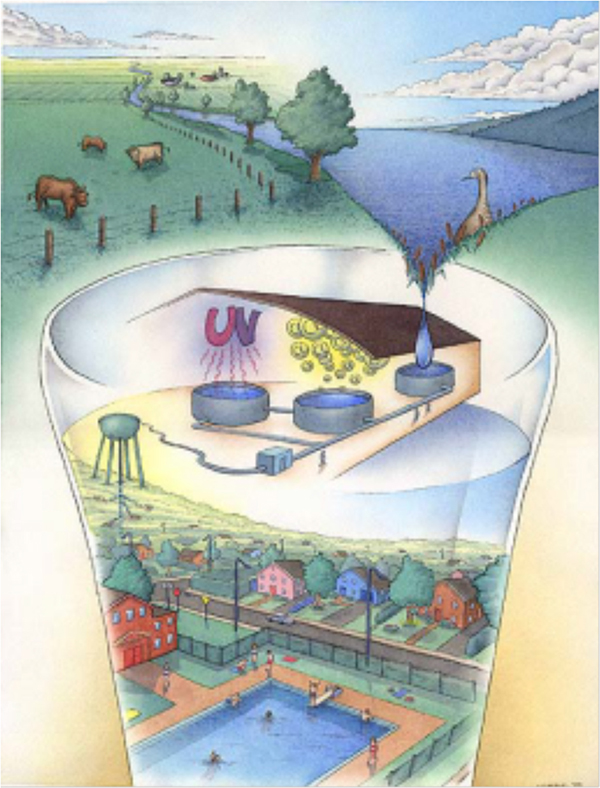
Figure 1: Multi-Barrier Approach
This image is a condensed representation of the multi-barrier approach, which is also often called the source to tap approach. The top of the image shows the components of a typical watershed, which includes agricultural land next to a lake. The bottom of the image shows a container into which water from the lake flows. The inside of the glass contains an image that represents some of the barriers of the multi-barrier approach including a water treatment system, a water distribution system made of an elevated tank and pipes, and water consumers represented by a neighborhood and a public pool.
1st Barrier: Source Water Protection
2nd Barrier: Water Treatment Technology
3rd Barrier: Distribution System Maintenance
4th Barrier: Water Quality Monitoring, and Testing
5th Barrier: Emergency Response Planning
What is a Source Water Protection Plan?
A source water protection plan (SWPP) is a document aimed at documenting how to protect source water quality and quantity. An SWPP is a systematic and organized assessment of contamination sources and pathways linked to human activity and natural processes that occur in a watershed. Based on this inventory, the SWPP identifies and prioritizes management actions to mitigate or reduce water contamination risks to an acceptable level.
"In order to protect drinking water quality and quantity, governments, organizations and communities are designing and adapting source water protection plans. A source water protection plan is a management strategy designed to minimize the impacts that human activities and natural events have on water sources. Such a plan should take a comprehensive ecosystem approach to water management, recognizing the need for clean drinking water, sustainable services for other human uses, and protecting the integrity of ecosystems."
How to Use This Document
This On-Reserve Source Water Protection Guide and Template (the Guide) is provided to First Nations wanting to develop their own community-based SWPP. The Guide is designed to provide step-by-step guidance to First Nations as they develop their SWPP. It is built around a generic SWPP template, provided in Appendix A, which proposes a standard structure for the plan. The template provides pre-written text and a series of tables that First Nations are invited to complete with their own community-specific information. Reference to this Guide, which provides necessary background and explanations, will assist in this process.
2. Background on Water Sources and Contamination Pathways
This section provides those involved in the development of an SWPP with basic concepts they need to understand to be able to follow and actively participate in planning sessions.
Types of Water Sources
Source water is the natural, untreated raw water found in aquifers and surface waters that are the source of drinking water. Source water contained in surface water supplies includes water found in lakes, rivers and other water streams. Groundwater is another source of raw water. Groundwater is water found beneath the earth's surface. The term "groundwater under the direct influence of surface water", or "GUDI" is often used to refer to a groundwater source that is located near enough to surface waters to receive direct surface water recharge. Everything is connected!
"The close relationship between surface and groundwater means that one cannot be affected in isolation of the other. If a water source becomes contaminated, there is a good possibility that the pollutants will eventually make their way into, and potentially contaminate, another water source."
Sources of Contamination
Both natural and human factors influence the quality of a water source. Where they exist, the nature and human-generated risks to source water present difficult challenges to the water treatment plant and may impact human and environmental health.
Water contamination from natural factors. Natural factors may contribute to drinking water contamination if left unchecked. Wildlife, for example, contains microorganisms such as bacteria, parasites and viruses that may cause diseases in humans. Ongoing changes to the natural environment such as wildfire, storm events, flooding and erosion can also introduce risk to source waters. Natural factors affecting water quality are often unpredictable and may occur very suddenly. For example, a severe rain storm may cause stream bank erosion and introduce sediments into source water, raising turbidity (cloudiness). Naturally occurring landslides may also impact water quality by adding debris and soil material causing high turbidity in the water. Human activity, such as forestry, urbanization, mining, and agriculture may exacerbate these natural conditions.
Water contamination from human activities. The quality of source water may be negatively impacted by past and present land use activities that introduce a risk to human and environmental health. Land use activities, including agriculture, may introduce pesticides and nutrients into water sources. Many residential activities also introduce potential risks to source water such as domestic animals, sewage disposal systems, landfills, lawn care, road networks, road salts, personal care products, pharmaceuticals and abandoned residential wells. Commercial and industrial activities add additional risks in the form of waste products, hazardous goods transportation, toxic by-products, dry cleaning wastes, car wash wastewater, fuel storage leaks, etc. Past industrial activity such as railroad routes, aging oil tanks, mine tailings, and other early industry may also contribute to water quality degradation. Figure 2 illustrates contamination pathways from human activity.
Figure 2: Human Activities Affecting Source Water

Figure 2: Human Activities Affecting Source Water
This image represents a watershed and includes surface water and groundwater sources along with human activities that can affect the quality of the source water. Overall, the image shows a schematic representation of multiple human sources of contamination, and for each, an arrow indicates the water contamination pathway with text that describes the nature of that contamination. In the background to the left the image shows atmospheric emissions from a plant, which are intercepted by clouds that contaminate water through acid rain. In the background to the right, the image shows a city that affects water sources through urban and landfill runoff. Similarly, the center of the image depicts agricultural land from which pesticides and manure contaminate water sources, as well as a hazardous waste dump site and in-ground septic and fuel tanks. Surface water sources are represented by water streams that emerge from mountains in the background and flow through a river into a lake illustrated at the forefront. The lake has a boat on it, indicating possible contamination from recreational boating. In turn, groundwater sources are represented at the forefront by a cut through the ground that shows wide blue arrows illustrating ground water flow and contamination migration towards a well.
In the context of developing an SWPP, water contamination that results from human activities is of greater interest because this type of contamination is the one over which the community has the most control. For this reason, let's take a closer look at those human-related factors to help facilitate their identification in the local watershed during the development of the SWPP. Human-related factors contributing to pollution are often divided into two categories: point source and non-point source pollution.
Point source pollution. Point source pollution is pollution that can be traced to a fixed point such as an effluent pipe, a smokestack, or a leaking fuel tank. Point source pollution enters the environment at a specific place from an identifiable source. A point source of pollution is something that you can "point" your finger toward, such as a sewage outfall pipe. Figure 3 below illustrates point source pollution originating from a landfill where leachate contaminates groundwater, which then feeds downstream source water. Other examples of point source pollution that you might need to consider for your SWPP include but are not restricted to:
- industrial point discharges, as well as spills and leaks of industrial chemicals;
- municipal wastewater effluents;
- landfill site leachate;
- wastes from existing and abandoned mining sites;
- on-site septic systems; and
- leaking underground oil and gas storage tanks.
Figure 3: Point Source Pollution: Contaminants from Landfill Sites

Figure 3: Point Source Pollution: Contaminants from Landfill Sites
This image shows a lateral cut through the ground that exposes a topography that slopes down from left to right to a spring pond and a water stream. Underlying the topography is a dotted line that indicates the water table level and an arrow that indicates groundwater flow direction towards the water streams. The top left part of the image shows a landfill site under which emerges a contamination plume that makes its way into water streams through contaminated groundwater flow. The bottom of the image provides a list of potential contaminants subject to this contamination pathway: pesticides, paint thinners, chemical cleaning compounds, oil, and other toxic substances.
Non-point source pollution. Non-point source pollution is pollution that cannot be traced to a fixed point such as recreation activity, roads, and urban runoff. Non-point source pollution is more difficult to identify and a much trickier problem to address in terms of land management practices to reduce contamination of source waters. Non-point sources of pollution come from multiple areas. These are sources you cannot exactly point your finger towards. Non-point sources are generally the result of water running over land that picks up natural and human-made pollutants and deposits these pollutants into surface waters or into groundwater through infiltration. Figure 4 illustrates non-point source pollution originating from agricultural runoff, which contaminates groundwater. Agricultural runoff can contain oil, grease, fertilizers, pesticides, bacteria and nutrients from livestock and manure. Other examples of non-point source pollution that you might need to consider for your SWPP include but are not restricted to:
- urban runoff from buildings, streets and sidewalks that carry sediment, nutrients, bacteria, oil, metals, chemicals, pesticides, road salts, pet droppings and litter;
- bacterial and petroleum products from recreational boating; and
- acid precipitation and other forms of air pollution that fall into surface waters and onto the land.
Figure 4: Non-Point Source Pollution: Agricultural Runoff

Figure 4: Non-Point Source Pollution: Agricultural Runoff
This image shows a lateral cut through the ground that exposes a flat topography of agricultural land use. In the center, a cut through what seems to be a body of water illustrates surface runoff and ponding. To the right, a farm and cattle illustrate a heavily used and poorly designed agricultural lot. The bottom of the image illustrates the bedrock underneath the body of water. A dotted line that goes across the image illustrates the water table level. The image shows a dark area that goes down from the agricultural lot into the water table, which illustrates groundwater contamination from agricultural land use. Similarly, an arrow at the surface level points from the cattle into the body of water to illustrate surface water contamination from agricultural runoff.
In Figure 4, non-point source pollution from a large agricultural area is disbursed over the landscape. Eventually, the contaminants from this agricultural activity enter source water at multiple points. These contaminants reduce the quality of source water, possibly to dangerous levels.
Types of Drinking Water Contaminants
Throughout this Guide, there is reference to drinking water contamination and the need to protect source waters against contaminants. The following provides basic information on the types of contaminants that originate from source contamination and are commonly found in untreated water. This section also describes typical contamination pathways, which can be useful when it comes to planning source protection efforts aimed at preventing contaminants from entering water sources.
There are five main types of drinking water contaminants: physical, microbiological, inorganic, organic and radioactive.
1. Physical Contaminants
Turbidity, or cloudiness, in water is caused by the presence of suspended particles such as clay, silt or microscopic organisms. Cloudy water is a problem because the particles in the water are a source of food for bacteria. Cloudy water can also interfere with the effectiveness of chlorination at eliminating pathogens in the water.
2. Microbial Contaminants
Human and animal wastes are the main sources of microorganisms, or microbial contaminants, which can cause diseases in water supplies. Improperly treated sewage, bird droppings, and runoff from farms and city streets are a source of microorganisms in drinking water. The following briefly describes the main microbial contaminants affecting drinking water:
Bacteria: While bacteria are present virtually everywhere, certain types that exist in untreated water may be pathogenic.
Campylobacter: Certain types of campylobacter may cause gastroenteritis (inflammation of the stomach and intestines). They are typically found in human and animal wastes, including bird droppings, and they often end up in water after a heavy rainfall.
Escherichia coli: E. coli is naturally present in human intestines and plays an important role in digestion. However, some forms of E. coli can cause gastrointestinal diseases, including a severe form of diarrhea that can lead to kidney failure and death. One way that E. coli ends up in water is from untreated sewage and agricultural land uses.
Giardia: In Canada, Giardia is the most common protozoa found in water. It causes a gastrointestinal disease known as giardiasis or "beaver fever," which can last for a long time. Symptoms of Giardia infection may include watery diarrhea, loss of appetite, dehydration, cramps and vomiting. Wilderness campers and others who drink untreated water are most susceptible to Giardia exposure.
Cryptosporidium: Another common protozoan, Cryptosporidium is very resistant to chlorination, but can be killed by boiling water. In humans it causes cryptosporidiosis, a disease with symptoms that may include diarrhea, stomach cramps and a mild fever. For people with a weakened immune system, cryptosporidiosis can be fatal.
3. Inorganic Contaminants
Inorganic, or non-living, water contaminants include various metals, arsenic and nitrates.
Metals: Metals may be naturally present in water from weathering and erosion or they may be present as a result of human activities, such as mining and manufacturing.
Arsenic: Arsenic may enter water bodies from smelting operations, the burning of coal and waste, and dumping of industrial wastewater. It may be in particles in the air, which then land in the water. It may also be present as a result of natural processes, such as weathering and erosion. Deep wells may be susceptible to naturally occurring arsenic contamination.
Nitrates: Nitrates occur naturally in water, resulting from decaying plant matter. Nitrates are also a main ingredient in commercial fertilizers and can end up in water via runoff from farmers' fields, septic systems and landfills. When homeowners apply fertilizers to their lawns and gardens, up to 50% of the nitrogen in the product ends up in nearby water sources (Pollution Probe 2002).
4. Organic Contaminants
Pesticides: Pesticides are chemical and biological agents that are used to control pests such as weeds, insects, rodents, fungi, bacteria and viruses. Pesticides are sprayed on crops, lawns and gardens, and golf courses. These chemicals can easily end up in drinking water sources.
Volatile organic compounds. Volatile organic compounds (VOCs) are among the most frequently detected organic contaminants in groundwater. VOCs are chemicals that readily evaporate and include such substances as trichloroethylene and tetrachloroethylene. These two chemicals are found in household products and are also used as solvents by the metal-degreasing and dry-cleaning industries.
5. Radioactive Contamination
Water may become contaminated with radioactive atoms (called radionuclides) from both natural and human sources. Exposure to such radionuclides is associated with a slight increased risk of cancer and genetic disorders (Pollution Probe 2002).
3. Step-by-Step Procedure to Develop a Source Water Protection Plan
Overview and Scope of the Procedure
The on-reserve SWPP supported by this Guide follows a five-stage process with the goal of producing a watershed assessment that includes the ranking of risks to the source water, identifying management actions to reduce those risks, and an implementation strategy to deliver on those management actions. The five stages are illustrated in Figure 5. In summary, the stages are:
- Stage 1: Establish an SWPP Working Committee
- Stage 2: Complete a Source Water Risk Assessment
- Stage 3: Identify Management Actions to address potential risks to your source water
- Stage 4: Develop an Implementation Strategy
- Stage 5: Review and update your SWPP approximately every 5 years
Figure 5: Source Water Protection Plan Process

This image graphically represents the five steps of the source water protection plan process, which are listed and presented in detail in the text below the image. The image shows arrows that form a circle. This circle illustrates the planning cycle.
Importance of taking a watershed approach to the protection of drinking water supplies. However, at this time, and to initiate local plan-making, its scope focuses on on-reserve source water protection planning. The source water protection plan developed from this Guide and the management actions arising from it are meant to be specific to on-reserve land and water areas. However, this should not limit the scope of First Nations inquiry only to on-reserve risks to source water. Potential contaminant threats that are off reserve, and of concern to the First Nation, should also be identified and recorded. In this way, potential risks that are off-reserve can be flagged in the plan for future consideration and action. In all cases, the First Nation is encouraged to enter discussion with other stakeholders and adjacent land owners off reserve to develop working relationships to address any potential risks to on-reserve source water.
In other words, the purpose of this Guide is to facilitate the undertaking of on-reserve source water protection planning while encouraging the First Nation to participate, where possible, in watershed-scale planning. If there is a major concern posing a risk to on-reserve source water, then the First Nation should make this issue a priority in their SWPP and commence dialogue with off-reserve stakeholders.
STAGE 1: Establish an On-Reserve Working Committee
Source water protection was founded on the concept that informed citizens, equipped with fundamental knowledge about their drinking water source and the threats to it, would be the most effective advocates for protecting source water. To achieve this, an On-Reserve Source Water Protection Working Committee (the Working Committee) needs to be established. The appointment of the Working Committee is an important first stage (Stage 1) in developing a source water protection plan.
Role of the Working Committee.
The Working Committee will oversee the process of developing the SWPP. The Working Committee will lead a locally driven, multi-stakeholder, science-based process to protect on-reserve drinking water sources while promoting water stewardship in the community. During development of the SWPP, the Working Committee will hold meetings, undertake field inspections, receive reports, and meet with community members.
Appointment of Working Committee Members
.Working Committee membership will ideally be broad and inclusive to include multiple perspectives and world views on water and the environment. Elders will be critical to the success of any on-reserve SWPP because they bring aboriginal traditional knowledge (ATK) about the watershed that is probably not documented anywhere. The incorporation of ATK, where appropriate for your First Nation, will enrich the source water protection plan. Historical, traditional, and ceremonial teaching of water should be recognized in the plan along with Western-science teachings. For example, a traditional celebration of clean water is a reminder of the importance of clean water and the purpose of doing source water protection planning. Youth and Elder engagement in such activities serves a role in both environmental education and traditional knowledge. Guiding principles for those serving on your Working Committee include trust, two-way communication, commitment, and honesty.
In Stage 1, members of the Working Committee need to be listed in a table for reason of transparency and openness. In addition, this list allows for easy reference in the future when SWPP gets reviewed and updated. Also, the list of members in Table 1 might be useful to track participants who may eventually serve on a future Working Committee when the plan is reviewed. Working Committee members may need to be consulted for information and details relating to the original plan. Table 1 provides a sample list and contacts for the Working Committee members appointed by the First Nation to serve on the SWPP.
| Name | Role in Community | Affiliation | Contact Information | Membership Start Date |
|---|---|---|---|---|
| name | Elder | <name> First Nation | Email, phone | Dec 1, 2012 |
| name | Councillor | <name> First Nation | Email, phone | Jan 12, 2013 |
| name | Lands Manager | <name> First Nation | Email, phone | Jan 12, 2013 |
| name | Youth | <name> First Nation | Email, phone | Jan 14, 2013 |
| name | Water Operator | <name> First Nation | Email, phone | Jan 14, 2013 |
Working Committee Meetings
The development of the SWPP will require regular meetings of the Working Committee followed by at least one Open House meeting in the community. The date, location and purpose of these meetings and events will be reported in Table 2. After each meeting, Table 2 should be updated in order to keep a complete record of events for the public and for the Working Committee. The total number of Working Committee meetings should be recorded in the SWPP. Additional information that cannot be included in Table 2 such as maps, documents, water quality reports, well logs, etc., but are of relevance to the SWPP should be retained in a working file along with the agenda and minutes of each meeting. A sample summary of the Working Committee meetings is presented in Table 2 for ease of reference.
The Working Committee's recommendations will form the basis of the SWPP and will be presented to the community for comment and discussion in at least one Open House session in the community. The purpose of the Open House meeting is to receive public feedback from the community on the content of the draft SWPP. The date of this Open House will also be reported in the SWPP. The SWPP should reference the date and location of the public Open House as well as the means by which the community was notified of the Open House, such as community posters, door to door flyers, public health clinic, school notices, local radio, newsletter, etc.
| Date YYY/MM/DD |
Location | Purpose |
|---|---|---|
| 2013/01/24 | <name> First Nation | Inaugural meeting of the working committee; to develop terms of reference; to select Chair; to determine timelines and future meeting dates; to prioritize, delegate workloads. To complete Stage 1. (Add greater detail as needed) |
| 2013/02 | <name> First Nation | Working Committee field inspection to review land use activities, treatment plant; wellhead areas. (Add greater detail as needed) |
| 2013/02 | <name> First Nation | Meeting of the Working Committee to complete source water assessment, including the assessment of risk. To complete Stage 2. (Add greater detail as needed) |
| 2013/02 | <name> First Nation | Meeting of the Working Committee to assign management actions to address risks identified in Stage 2. Completion of Stage 3. (Add detail as needed) |
| 2013/03 | <name> First Nation | Meeting of the Working Committee to develop implementation strategy. Completion of Stage 4. (Add greater detail as needed) |
| 2013/03/27 | <name> First Nation | Public Open House in community. All Working Committee members in attendance to explain the plan. |
Ongoing Communication
It will be essential for the Working Committee to receive input from the community after the Open House using a comment sheet, email or community link to the SWPP website hosted by the First Nation. Either way, every effort should be made to address comments from the public respecting the draft SWPP prior to its finalization. The Working Committee will be at the centre of the planning process. A successful SWPP will require time commitment, teamwork, and attention to detail. Take time to ensure that Stage 1 of the SWPP gets off on the right foot!
STAGE 2: Complete a Source Water Risk Assessment
As a Working Committee member, during Phase 2 you will seek input from SWPP participants to identify important features of your community water sources and you will identify, describe, assess and prioritize the risks associated to contamination sources. Stage 2 of the SWPP development contains several important sub-stages and will perhaps represent the most time-consuming and demanding portion of the initiative. Stage 2 is quite substantial, but it will provide your SWPP with a solid foundation upon which source protection measures, the next stage, can be developed. The following presents the five sub-stages that are covered in this section:
- Sub-stage 2.1: Delineation of drinking water sources and systems
- Sub-stage 2.2: Description of drinking water systems
- Sub-stage 2.3: Inventory and Description of potential contamination sources
- Sub-stage 2.4: Assessment of source contamination risks
- Sub-stage 2.5: Prioritization of source contamination risks
Stage 2 requires a good knowledge of watershed features located in the community and the role of the Working Committee will be instrumental in collecting this knowledge from participants and compiling it into the SWPP. This section will show you how to do this—just follow the Guide!
Sub-stage 2.1: Delineation of Water Sources and Systems
Stage 2 begins with an overview of the on-reserve portion(s) of the watershed(s) from which drinking water is drawn in your community, as well as the systems that collect that water, treat it, and distribute it to community users. The goal of this phase is to delineate the water sources, identify drinking water systems, and to record this information on a map.
Source delineation, Source delineation refers to the process of drawing the boundaries of a watershed on a map. This can easily be done by using a topographic map, which shows elevations (and therefore hills and slopes), and figuring out which portions of land on the reserve feed the water streams when surface runoff occurs during and after a rainfall event. Once this is done, the Working Committee should prepare a map that clearly shows the watershed delineations as well as all watercourses and their source. The SWPP map should be developed as an appendix to the final SWPP.
Mapping of drinking water systems
A general description of the community's drinking water system(s) should also be reported during this phase. By extension to source delineation mapping, the location of wells, as well as the location of the community's drinking water system infrastructure (e.g., water intake structure, treatment plant, pumping /chlorination stations and distribution system ramifications) should also be added on the SWPP map.
Use of existing information will assist describing water systems in place. The purpose is to give each member of the Working Committee and the community at large, a general understanding of the water system(s). In a single paragraph, the type of information to be collected includes but is not limited to:
- Total population figures and projections
- Number and location of water systems
- Number of drinking water service connections
- Type of water treatment
- Number and location of community and private wells
- Age and history of the water system(s)
- Description of water sources
- Information on water quality (physical, biological, chemical parameters, if available)
- Seasonal water availability
Mapping of other watershed features
As well, additional information on the natural and human conditions of the water source area should be described in a short text and also added to the SWPP map where possible, for example:
- Reserve boundaries
- The physical terrain and geological characteristics of the source water area
- Dominant land use activities
- Vulnerable surface water or groundwater recharge areas
- Community roads and associated bridges and culverts
- Community buildings, etc.
Mapping of source protection areas.
In support of source delineation and other watershed features incorporated on the SWPP map, it is a valuable exercise to also indicate on this map the likely protection areas associated with the water sources. A source protection area represents a zone or perimeter of influence around a water intake or a wellhead, where eventual contaminants are likely to negatively impact the quality of water. Another way to look at it, from an SWPP standpoint, is that drawing source protection areas on the SWPP map may put to light and make visually evident the interaction between potential contamination sources (Sub-stage 2.3) and water intake zones, and may also help targeting actual protection measures (Stage 4) where they can have the biggest impact.
Ideally, the identification of source protection areas should be informed by hydrological and hydrogeological studies. However, those can get quite complex and expensive. Nevertheless, some simple rules of thumb and assumptions can be applied as part of an SWPP, which can still result in substantial benefits to water quality. For example, some regulations in Ontario prohibit the deposit of waste within 50 meters of a wellhead. This criterion could be used in an SWPP to map source protection areas around wells.
Once this work is done, it will become clear which parts of the watershed are located on reserve and which parts of it could be impacted by surrounding land use activities. The following explanations and figures might also help you to develop source protection areas for your SWPP.
What is a Wellhead Protection Area?
A wellhead is the physical structure of the well above the ground. A wellhead protection area is the area surrounding the wellhead through which contaminants can move into the well. The various zones that make up a wellhead protection area are based on how long it would take a contaminant to get into the well. This is illustrated in Figure 6.
- 100 metre area: The area where the risk to the well is highest.
- 2 year time of travel: In the second ring, bacteria and viruses from human and animal waste are a concern.
- 5 year time of travel: Biological contaminants are less of a concern in the third ring but chemical pollutants are a concern.
- 25 year time of travel: The most persistent and hazardous pollutants remain a concern.
Figure 6: Wellhead Protection Area

Courtesy: Conservation Ontario
Figure 6: Wellhead Protection Area
This image represents both surface agricultural land and the underlying soil. At the top of the image, the agricultural land is illustrated by a farm, cattle, crops and a wellhead. The underground shows layers of soil and the well's stand pipe that goes across them. At the surface, on top of the landscape illustration, four concentric circles surround the well head. Starting from the wellhead location, each circle is tagged respectively with a 100 meter zone, a 2-year time of travel, a 5-year time of travel, and a 25-year time of travel, which supports the explanatory text located above this figure.
What is an Intake Protection Zone?
Intake Protection Zones are the areas of land and water that are upstream of a water intake. In this area, special care must be taken in the use and handling of potential contaminants. This is illustrated in Figure 7.
- Intake Protection Zone 1 (IPZ-1) is the area considered the most vulnerable to any contaminant of concern.
- Intake Protection Zone 2 (IPZ-2) is considered high risk as any contaminant that is spilled in this zone has a high probability of reaching the intake within 2 hours and adversely affecting the water quality.
Figure 7: Intake Protection Zone

Courtesy: Conservation Ontario
Figure 7: Intake Protection Zone
This image illustrates a city and an adjacent river. The left of the image shows the municipality, represented by downtown buildings and a residential area. The right of the image shows a river that is divided into two areas: one called IPZ-1 towards the bottom, in which a municipal source water intake pipe is illustrated; and another area called IPZ-2 towards the top of the image, in which two municipal wastewater discharge pipes are illustrated. Those two areas support the text about water intake protection zones, located above the figure.
Sub-stage 2.2: Description of Drinking Water Systems
This sub-stage requires the Working Committee to expand on information collected in Sub-Stage 2.1 and gather detailed information on the community's drinking water systems. Information on groundwater systems should be compiled using Table 3A and information on drinking water systems that use surface water should be compiled using Table 3B. The Working Committee should rely on existing sources of information to complete these tables. Possible sources of information could include, but are not restricted to, the Band Office, Public Health office, Elder knowledge, technical reports, water treatment plant operators, Circuit Riders, local knowledge, and direct measurement. Tables 3A and 3B below contain sample text. Equivalent blank tables to be filled for your SWPP are provided in Appendix A.
| Assessment Questions | Well No. 1 | Well No. 2 | Well No. 3 | Etc. |
|---|---|---|---|---|
| Well Record ID # | #001234 | #001235 | #001236 | |
| Well depth (m) | 45 m | Etc. | ||
| Depth to groundwater (m) | 25 m | |||
| Confined/unconfined aquifer | unknown | |||
| Depth to bedrock (m) | unknown | |||
| Depth of casing (m) | 20 m (est.) | |||
| Well owner | First Nation | |||
| Population served | 325 | |||
| Date of construction | 1974 (est.) | |||
| Is water treated? | yes | |||
| Treatment type | chlorination | |||
| Wellhead access secured? (fence, cap locked) | no | |||
| Wellhead enclosed by wellhouse | no | |||
| Yes – wellhead access controlled? | n/a | |||
| No – permanent grass buffer at least 3 m around well? | yes | |||
| Does surface water pool around well? | Sometimes yes | |||
| Well casing extends at least 0.3 m above mounded earth | no | |||
| Wellhead seal is secure, in good condition | yes | |||
| Fuel storage in wellhouse? | n/a | |||
| Wellhead protection zone currently in place? | Not yet! |
| Assessment Questions | Source No. 1 | Source No. 2 | Source No. 3 | Etc. |
|---|---|---|---|---|
| On-reserve location (local reference) | NW corner of First Nation | Etc. | Etc. | |
| Name of source water (lake, stream) | Smith Lake | |||
| Intake location | SE end of lake | |||
| Backup intake available? | No | |||
| Frequency of intake inspection? | Annually (estimate) | |||
| Intake screened? | yes | |||
| Population served | 220 | |||
| Date of construction | 1987 (estimate) | |||
| Is water treated? | Yes | |||
| Treatment type | Chlorination Filtration |
|||
| Backup source available | Not at this time | |||
| Raw water monitored? | Yes | |||
| Yes - Frequency, parameters? | Annual, physical, chemical parameters | |||
| Intake protection zone in place? | No |
Sub-stage 2.3: Inventory and Description of Potential Contamination Sources
While Sub-stage 2.1 required the mapping of water sources and other on-reserve watershed features such as reserve boundaries and dominant land use activities, Sub-section 2.3 aims at using the SWPP map (to be provided as an Appendix to the SWPP) to think through and identify all potential contamination sources.
The Working Committee, in consultation with the community, will provide a contaminant source inventory of all on-reserve land uses and activities with potential to degrade water quality. This inventory needs to be listed in Table 4A and shown on the SWPP map. Potential contamination sources to consider include:
- Climate change
- Erosion, flooding and other natural factors
- Wastewater treatment plant and sewage outfall locations
- Sewage lagoons
- Landfills and other waste deposits
- Agriculture
- Fuel storage
- Housing, industry and commercial uses, etc.
- Any other known or perceived land use impacts that may affect source water quality
| Land Use Activity or Natural Condition with Potential to Contaminate Water Supply (examples only) |
Location of Activity Relative to Source of Water, Wellhead, or Intake to Water System (shown on SWPP Map) |
|---|---|
| Fertilizers, pesticides | See Appendix - SWPP map |
| Faulty septic fields | See Appendix - SWPP map |
| Former industrial sites | See Appendix - SWPP map |
| Streambank erosion | See Appendix - SWPP map |
| Cattle access to river | See Appendix - SWPP map |
| Fuel storage and pipelines | See Appendix - SWPP map |
If desired, the Working Committee may also provide an inventory of off-reserve land uses and activities of concern with potential to degrade on-reserve water quality. This inventory may be listed in Table 4B and shown on the SWPP map.
| Land Use Activity or Natural Condition with Potential to Contaminate Water Supply (examples only) |
Location of Activity Relative to Source of Water, Wellhead, or Intake to Water System (shown on SWPP Map) |
|---|---|
| Adjacent feedlot | See Appendix - SWPP map |
| Adjacent urban development | See Appendix - SWPP map |
| Adjacent mining activity | See Appendix - SWPP map |
Background information on water sources and contamination pathways presented in Section 2 (Background) can be useful to identify the contamination sources:
- point source (contamination from a specific point, e.g., effluent pipe);
- non-point source (contamination from a broad area, e.g., road run-off); and
- natural factors such as erosion or natural flooding.
In particular, information and figures of Section 2 describing point source and non-point source pollution, as well as the information provided on the contaminants and their pathways can support this exercise.
Using the format shown in Table 5, the Working Committee will further document potential contamination sources by noting contaminant source, land owner, distance to source water, contamination of concern, and transport mechanism for each of point source, non-point source and natural source of contaminant. There is no need to present contamination sources in any particular order at this point; the next sub-stages will deal with the assessment and ranking of the contamination sources.
| Contaminant Source | Owner | Distance to Source (m) | Contaminants of Concern | Transport Mechanism |
|---|---|---|---|---|
| Point Sources | ||||
| Landfill leachate | First Nation | 25 m | Paints, metals, oils | Surface water |
| Abandoned mine | Crown | 100 m | Cyanide, arsenic | Pond burst |
| Septic leachate | Private | 5 m | E. coli bacteria | Groundwater |
| Non-Point Sources | ||||
| Agriculture | ABC Farms | 0 m | Fertilizers, pesticides | Water |
| Rural Runoff | Private | 0 m | Oils, antifreeze, animal waste | Stormwater |
| Recreational boating | First Nation | 0 m | Oil, gas, human waste | Water |
| Natural Sources | ||||
| Streambank erosion | First Nation | 0 m | turbidity | |
| Heavy rains/drought | First Nation | 0 m | Flooding, turbidity/low flow events | |
Sub-stage 2.4: Source Water Risk Assessment
Building on the previous sub-sections, which described and mapped the location of all potential contamination sources, in Sub-section 2.4 the Working Committee will now quantify the human health risks associated with each of the contamination sources. A risk assessment is a technique that allows for any given human health risk to be assigned a relative magnitude against other risks. Using this numeric scale to assess the relative magnitude of each potential risk, the Working Committee is to rank the risks from highest to lowest (Sub-Stage 2.5) and then to prioritize risk management actions aimed at reducing those risks (Stage 3).
The risk assessment exercise of Sub-Stage 2.4 simply consists in taking each of the contamination sources listed in Table 5 and assigning them a "Likelihood" score and an "Impact" level score. The resulting risk magnitude (or risk assessment score) will be determined by multiplying the "Likelihood" by the "Impact." To do this and complete the risk assessment, the Working Committee needs to follow three simple steps. These steps are described below.
Step 1 ─ Likelihood:
The Working Committee will use Table 6 to match the Likelihood for each contaminant source in Table 5 (Column 1). This will provide a numeric value for each contaminant source ranging from 1 to 5, with 5 being the most severe. Determining this value will involve collaboration among the Working Committee, consultation with the community including Elders, site inspections, and also possibly outside expert advice.
| Likelihood | Value |
|---|---|
| Most unlikely Extremely small chance of happening in the next 4-5 years |
1 |
| Unlikely Is possible to occur in the next 4-5 years |
2 |
| Likely Evenly split between likely and not likely to happen in the next 4-5 years |
3 |
| Probable Is expected to happen in the next 4-5 years |
4 |
| Almost certain Confident this will happen at least once in the next 4-5 years |
5 |
| Potential Risk to Source Water |
Working Committee Comments | Likelihood Value |
|---|---|---|
| Contamination from agriculture | The Working Committee members all agreed that agriculture in the area of a community water supply poses an almost certain likelihood of agriculture runoff occurring at the source in the next 4-5 years | (Event occurs at least once in 4-5 years) Ranking: 5 |
| Contamination from recreational activities (e.g. boating on lake source) |
Conversely, the Working Committee members all agreed that recreational boating has not, to date, raised problems on the lake and the likelihood of contaminants being deposited in the water source is most unlikely in the next 4-5 years | (Event rarely occurs) Ranking: 1 |
| Etc. |
Step 2 ─ Impact:
The Working Committee will use Table 7 showing the Impact of Occurrence and associated value (1-5). The Working Committee will match the impact of occurrence for each contaminant source in Table 5 (Column 1). This will provide a numeric value, or ranking, for each contaminant source ranging from 1 to 5, with 5 being the most severe. Determining this value will involve collaboration among the Working Committee, consultation with the community including Elders, site inspections, and also possibly outside expert advice.
| Impact | Value |
|---|---|
| Insignificant No health risk; water system interruption less than 8 hours |
1 |
| Minor Short term or localized non-compliance, non-health related, e.g., aesthetic |
2 |
| Moderate Widespread aesthetic issues or long term non-compliance, not health related |
3 |
| Severe Actual illness or potential short to medium term health effects (human or ecosystem) |
4 |
| Catastrophic Actual illness or potential long term health effects (human or ecosystem) |
5 |
| Potential Risk to Source Water |
Working Committee Comments | Impact Value |
|---|---|---|
| Agriculture | The working Committee members all agreed that runoff arising from agriculture in the area of a community water supply represents a severe health impact | Potential for Major Illness Value: 4 |
| Contamination from recreational activities (e.g. boating on lake source) |
Conversely, the Working Committee members all agreed that contaminants deposited in the water source through recreational boating represents a minor health impact | Minor Health Risk Value: 2 |
| Etc. |
Step 3 ─ Risk Assessment Score:
Once the Working Committee has agreed on a numeric ranking for both the Likelihood (Table 6) and the Impact (Table 7), the two can be multiplied together to determine a Risk Assessment Score.
Doing the Math!
Likelihood x Impact = Risk Assessment Score
Determining a Risk Assessment Score will require the Working Committee to consider the "Likelihood" of a specific event occurring as well as the human or environmental "Impact" of that event. Multiplying these two parameters together will give you the Risk Assessment Score!
Table 8 is a risk analysis matrix that provides a quick reference for the Working Committee to understand the implications of the Risk Assessment Score. By matching the Likelihood value (side column) with the Impact value (top column), the Working Committee can easily determine the Risk Assessment Score. The Risk Assessment Score is simply the product of Likelihood multiplied by Impact. The colour coding in Table 8 provides an indication of "High Risk" (red), "Medium Risk" (yellow) and "Low Risk" (green).
A high likelihood of an event occurring does not necessarily mean a high risk to human or ecosystem health. High risk means the combination of high likelihood AND high impact. For example, a high likelihood of a summer flood event that will have only a minimal impact on source water quality would pose only a minimal health risk.
| Likelihood of Occurrence | Impact of Occurrence | ||||
|---|---|---|---|---|---|
| Insignificant 1 | Minor 2 | Moderate 3 | Severe 4 | Catastrophic 5 | |
| Most Unlikely 1 | 1Low | 2Low | 3Low | 4Medium | 5Medium |
| Unlikely 2 | 2Low | 4Low | 6Medium | 8Medium | 10High |
| Likely 3 | 3Low | 6Medium | 9Medium | 12High | 15High |
| Probable 4 | 4Medium | 8Medium | 12High | 16High | 20High |
| Almost Certain 5 | 5Medium | 10High | 15High | 20High | 25High |
Sub-stage 2.5: Risk Ranking
Using the risk analysis matrix (Table 8), the Working Committee can rank (or prioritize) each of the risks associated with contamination sources. The ranking of those risks may be organized in Table 9 from highest to lowest. This process will provide useful information to be shared with the community in the Open House.
At this point in the SWPP process, the Working Committee will have a complete list of known risks to source water quality and related risk implications. Table 9A will list the risk rankings from highest (25) to lowest (1). This is a 25 point ranking system. But bear in mind: these are relative values having no direct meaning; rather, they have a relative value that allows for the ranking of one risk against that of another. The ranking process is only meant to enable the prioritization of management actions to address those risks.
Low rankings, perhaps 1 to 5, may represent risks which the Working Committee and First Nation community can tolerate. Higher risk rankings, say 10 to 25, may be important enough to trigger immediate attention to be addressed in ranked order. The Working Committee will decide where to set the tolerance for acceptable and not acceptable risk when it comes to determining management actions and implementation prioritization (Stage 4).
| Contaminant Source (from Table 5) |
Likelihood | Impact | Risk Ranking (Likelihood x Impact) |
|---|---|---|---|
| Agriculture | 5 | 4 | 20 |
| Landfill leachate | 4 | 5 | 20 |
| Private septic systems | 4 | 4 | 16 |
| Arsenic groundwater | 3 | 5 | 15 |
| Streambank erosion | 2 | 4 | 8 |
| Summer recreation | 1 | 3 | 3 |
| Winter recreation | 1 | 2 | 2 |
If desired, the Working Committee may also identify those off-reserve activities that pose a risk to source water, such as upstream urban development, industrial mineral extraction, or other. These activities may be listed with a risk ranking in Table 9B.
| Contaminant Source (from Table 5) |
Likelihood | Impact | Risk Ranking (Likelihood x Impact) |
|---|---|---|---|
| Adjacent feedlot | 4 | 4 | 16 |
| Adjacent urban growth | 3 | 3 | 9 |
| Adjacent mining activity | 2 | 4 | 8 |
The following stage, Stage 3, addresses on-reserve management actions necessary to eliminate or reduce the risks identified in the source water risk assessment.
STAGE 3: Identify Risk Management Actions
Upon completion of the source water risk assessment (Stage 2), the Working Committee should proceed to develop a management action plan aimed at reducing all significant risks to an acceptable level. Acceptable levels of risk will vary between First Nations communities and perhaps between individual members of any Working Committee. The important point is to get to a level of consensus regarding risk assessment and management actions. It is important to note that not all risks can be eliminated.
Using Table 9A and Table 9B, the Working Committee will identify on and off-reserve risk management actions for each of the risks. The number and the extent of management actions will vary depending upon the final Risk Ranking. Depending on where they rank on the list, some risks may warrant multiple management actions, whereas others may require only minimal control efforts.
There are many examples of management actions for the protection of source water. A list of examples is provided in Table 10 for convenience. The correct management action will depend on the specific site and situation. In some instances the correct management action may be unknown, causing the Working Committee to use a mix of management actions and to monitor changes to water quality and land use conditions over time. In Table 10, management actions have been arranged by "immediate actions" and "longer term" actions. This allows the Working Committee to decide on taking immediate action to reduce potential risk in some areas in order to gain momentum and yield early implementation success.
| Activity | Source | Management Actions |
|---|---|---|
| Agriculture | ||
| Animal feedlots | Waste Lagoons Land application Pasture areas |
Immediate actions: Buffer and setback zones Best management practices nutrient load standards Education Water quality monitoring Longer term: Health regulations Discharge requirements |
| Cattle grazing | Instream water use, overland flow | Immediate actions: Fencing Off-stream watering Education Longer term: Health regulations Land use zoning |
| Fertilizers | Land Application | Immediate actions: Buffer and setback zones Education Longer term: Health regulations Application standards |
| Irrigation | Return flows to groundwater, surface water | Immediate actions: Best management practices Education Longer term: Agricultural management |
| Construction | ||
| Residential Commercial |
Runoff from disturbed land Runoff from impervious surfaces |
Immediate actions: Buffers and setbacks Education Long term: Floodplain management First Nation zoning bylaw |
| Industrial transportation | Runoff from disturbed land Runoff from impervious surfaces |
Immediate actions: Buffers and setbacks Education Longer term: First Nation building codes Impervious surface limits First Nation zoning codes |
| Forestry | ||
| Harvesting operations | Road construction Runoff from disturbed sites |
Immediate actions: Buffers and setbacks Grass swales, runoff ponds |
| Fire Management | Ash and sediment runoff | Immediate actions: Buffers and setbacks Education Longer term: Pollution prevention, education |
| Industry | ||
| Storage tanks | Hazardous materials and waste | Immediate actions: Buffer and setbacks Education Longer term: Industry regulations Restoration, remediation Emergency Response Plan |
| Landfill | Hazardous material | Immediate actions: Waste separation Landfill monitor Fencing, signage Water quality monitoring Education Longer term: Runoff ponds First Nation zoning codes Pollution prevention, education |
| Pipelines | Hazardous materials and waste | Longer term: Utility regulations Emergency Response Plan |
| Brownfield sites (former industrial sites) |
Petroleum release Hazardous materials |
Immediate actions: Buffer and setback zones Water quality monitoring Longer term: Restoration, remediation Pollution prevention |
| Mining | ||
| Legacy mine sites | Tailing piles; hydrocarbon release; mine drainage | Immediate action: Water quality monitoring Longer term: Restoration, remediation Runoff ponds and wetlands |
| Stockpiles | Quarrying; mine drainage | Immediate actions: Buffer and setback zones Water quality monitoring Longer term: Pollution prevention Education |
| Urban (commercial and residential) | ||
| Fuel storage tanks | Hazardous materials, hydrocarbon releases | Immediate actions: Buffer and setbacks Education Water quality monitoring Longer term: Re-siting, remediation Education Floodplain management |
| Cemeteries and graveyards | Chemical and pathogenic contaminants | Immediate action: Buffer and setbacks Longer term: Health regulations Remediation |
| Septic tanks | Individual homes, businesses, multi-family units | Immediate actions: Pump-out regulations Setbacks, construction standards Education Longer term: Review health regulations Design standards Implement subdivision regulations Site design On-site wastewater regulations |
| Impervious surfaces | Runoff from roads, parking lots | Immediate actions: Grass swales, infiltration basins Education Longer term: Subdivision requirements, site design Building regulations Stormwater management |
| Surface impoundment | Sewage lagoons | Immediate actions: Site inspection Professional report Water quality monitoring Longer term: Health regulations Site design, floodplain management Subdivision regulations Inspections |
| Mono-culture lawns | Nutrients, pesticides | Immediate actions: Reduce lawn cover Landscaping Education |
| Groundwater | Unused or abandoned wells | Immediate actions: Well decommissioning Site remediation |
| Human wellness | Aboriginal Traditional Knowledge | Community water celebration Elder stories linking water and health Water spirit knowledge |
Using Table 10 as a guide, the Working Committee can allocate specific management actions to the risks previously identified. These proposed management actions will be listed in Table 11A. Multiple management actions may be suggested for immediate and longer term action.
| Risk Ranking | Potential Risk to Source Water | Existing On-Reserve Management Actions |
Proposed On-Reserve Management Actions |
|---|---|---|---|
| 20 | Agriculture | None | Immediate action: Examine buffer widths for agriculture |
| 20 | Landfill leachate | Voluntary waste separation, some products | Immediate actions: Waste separation Landfill operator Fence and security gate Longer term: Landfill relocation Water quality monitoring |
| 16 | Private septic systems | 5 year tank pump out | Immediate actions: Tank inspection Re-siting septic fields Longer term: Connect to community wastewater system |
| 15 | Arsenic groundwater Private wells |
None | Immediate actions: In-line filtration Temporary source Water monitoring Longer term: Find alternate water source Connect to community water system |
If desired, the Working Committee may list possible off-reserve management actions in Table 11B for future consideration with watershed-level stakeholders.
| Risk Ranking | Potential Risk to Source Water | Existing Off-Reserve Management Actions |
Proposed Off-Reserve Management Actions |
|---|---|---|---|
| 20 | Agriculture | None | Immediate actions: Examine buffer widths for agriculture |
| 20 | Landfill leachate | Voluntary waste separation, some products | Immediate actions: Waste separation Landfill operator Fence and security gate Longer term: Landfill relocation Water quality monitoring |
| 16 | Private septic systems | 5 year tank pump out | Immediate actions: Tank inspection Re-siting septic fields Longer term: Connect to community wastewater system |
STAGE 4: Develop an Implementation Strategy
An implementation strategy is necessary to make sure that the SWPP gets executed and to benefit from the momentum and community interest sparked during its development. An implementation strategy is about assigning roles and responsibilities, developing an implementation schedule, allocating resources, and putting in place a monitoring program to measure if the SWPP is having its intended impacts and to make necessary adjustments.
Details concerning the necessary stakeholders, funding sources and implementation timelines may have already been identified by the Working Committee while discussing source contamination risks (Stage 2) and possible risk management actions (Stage 3). Or perhaps those issues deserve separate discussions among Working Committee members. The Working Committee will record implementation aspects of the SWPP in Table 12.
| Risk Ranking (Highest to Lowest) |
Potential Risk to Source Water | Recommended Management Actions | Stakeholders/ Partnerships |
Proposed Timeline |
|---|---|---|---|---|
| 20 | Agriculture | Buffer zones Regulations Education |
Farmer Ministry of Agriculture |
Complete: 2 year |
| 20 | Landfill leachate | Re-siting of landfill Waste separation Education |
Community Public Health FN Environment |
Complete: 4 years |
| 16 | Private septic systems | Education Connect to community waste water system Increase maintenance |
Septic haulers FN Health Homeowners |
Complete: 4 years |
| 15 | Arsenic Groundwater Private wells |
Alternate water source | Private homeowners FN Environment Well drillers |
Complete: 2 years |
| Continue |
4.1 Water Quality Monitoring Program
Water quality monitoring provides baseline information to report changes in water quality over time at any location. A water quality program that targets specific areas of known concern across the community is encouraged. Community-based monitoring (implies community residents becoming involved in water monitoring), record keeping and information sharing is also encouraged. As a minimum, raw water quality should continue to be closely monitored at the water treatment plant to record and report changes to water quality over time.
It is difficult to determine the effectiveness of local source water protection efforts unless a record of water quality is kept. Tracking the effectiveness of protection efforts lets a community know if they are making improvements and allows the source protection plan to adapt to new information and changing conditions.
4.2 Communication Program
An SWPP communication program has two purposes. The first is to inform the community-at-large of the on-reserve SWPP. This could be achieved through school-based classroom activities to educate youth on source water protection. Other ways to communicate the SWPP to the community and also to external stakeholders include: local newspapers, bill-stuffers, flyers, posters, website and radio. The second purpose of an SWPP communication plan is to implement specific management actions within the plan: providing advice to households, industry and businesses on best management practices (BMPs) to protect source water will be an important part of SWPP implementation. This is also an opportunity to promote traditional knowledge on the subject of water by engaging Elders with all community members, especially youth.
STAGE 5: Source Water Protection Plan Review and Update
Your SWPP is a living document that should be reviewed and updated as necessary over time. On a five year cycle, the Working Committee needs to undertake a full review of the SWPP. This review will commence with the appointment of a new Working Committee that will be tasked to proceed with Stages 2 through 4 revisions. While some aspects of the SWPP may not change, the Working Committee should be open to new membership and any revisions that may occur to the source water assessment (Stage 2) and the development of revised risk management actions (Stage 3). As a result, the implementation strategy (Stage 4) may need to be updated accordingly.
5.1 Update Working Committee Membership
The first stage of any plan review would involve an update of the Working Committee membership. Ideally some members from the earlier Working Committee would resume as members to maintain plan content history and plan-making process knowledge.
5.2 Invite Watershed Stakeholders
During the earliest stages of developing or reviewing a plan, the Working Committee should attempt to make contact with all relevant stakeholders with an interest in land use activities that may impact source water quality or quantity. These stakeholders may include off-reserve groups, industry, government agencies or land owners. The goal from the outset is always to build as much information as possible about factors influencing on-reserve source water.
5.3 Update On-Reserve Source Water Assessment
If not done as part of the initial SWPP, the Working Committee should eventually consider sources of off-reserve contamination as part of SWPP updates. The Working Committee may engage with other off-reserve watershed committees to build working relationships that would facilitate information sharing. The Working Committee will also revisit the on-reserve land use inventory, update the water system inventory and recalibrate, if necessary, the likelihood and impact scores and risk ranking for all land uses and potential contaminants.
5.4 Review Water Monitoring
A monitoring program, or community-based water monitoring program, should be designed to provide feedback to the Working Committee on water quality and quantity. This information would then help inform decisions on the success of specific management actions and the need to make adjustments to management actions and therefore to update the SWPP accordingly.
5.5 Monitor Plan Implementation
The SWPP review process undertaken in Stage 5 should examine the rate of implementation of management actions. This process should be designed to identify capacity needs to help advance plan implementation. Financial, human, technical and other forms of capacity building may be identified in this process that could help advance implementation of management actions.
4. References
- Canadian Council of Ministers of the Environment. 2004. Source to Tap. The multi-barrier approach to safe drinking water. Prepared by the Federal-Provincial-Territorial Committee on Drinking Water.
- Chiefs of Ontario. 2006. Aboriginal Traditional Knowledge and Source Water Protection: First Nations' Views On Taking Care of Water. Prepared by Giselle Lavalley for Chiefs of Ontario and Environment Canada.
- Conservation Ontario. Figure 6 and Figure 7.
- Government of Ontario. Preparing Source Water Protection Plans. June 23, 2010.PIBS 7637e.
- Government of Ontario. April 2008. Drinking Water Source Protection. A Guide to Drinking Water Source Protection in the Lake Erie Protection Region.
- Government of Ontario. 2011. Drinking Water Source Protection. Drinking Water Source Protection.
- Health Canada. 2003. Guidelines for Canadian Drinking Water Quality: Supporting
- Documentation — Turbidity. Water Quality and Health Bureau, Healthy Environments and Consumer Safety Branch, Health Canada, Ottawa, Ontario.
- Kundell, J. and DeMeo, T. 2000. Source Water Protection: A Guidebook for Local Governments. The University of Georgia
- Nova Scotia Environment Water and Wastewater Branch 2004. Developing a Municipal Source Water Protection Plan: A Guide for Water Utilities and Municipalities.
- Nova Scotia Environment. 2009. Developing a Municipal Source Water Protection Plan. Steps 1-5.
- Pollution Probe. 2002. The Drinking Water Primer.
- Pollution Probe. 2004. The Source Water Protection Primer.
- Simms, G., Lightman, D. and de Loë, R. 2010. Tools and Approaches for Source Water Protection in Canada. Governance for Source Water Protection in Canada, Report No. 1. Waterloo, ON: Water Policy and Governance Group.
- Six Nations of The Grand River Source Water Protection Plan. 2007. Six Nations Council. Ohsweken, ON. Six Nations of The Grand River
- State of Colorado. Colorado Department of Public Health and Environment. Source Water Protection Template.
- State of Pennsylvania. 2000. PA Rural Water Association. Source Water Protection Template.
- Triton Environmental Consultants Limited. 2006. Chapman Creek Watershed Drinking Water Source Assessment. Prepared for the Sunshine Coast Regional District, BC, Canada.
- US EPA. May 2000. Community Involvement in Drinking Water Source Assessments. Office of Water (4606). EPA 816-F-00-025
Appendix A:
Source Water Protection Plan Template
<insert First Nation name here>
On-Reserve Source Water Protection Plan
<insert First Nation Address, Contact information here>
<Insert community photo as appropriate>
FOREWORD
Water is essential to all life. The risk to human health and to the natural environment from the contamination of water sources is a concern to
<insert First Nation name here>.
As a result, the
<insert First Nation name here>
has developed this on-reserve Source Water Protection Plan (SWPP) to protect drinking water sources from harmful contamination and to provide a healthy environment.
Source water is untreated water from groundwater or surface water sources that supplies drinking water for human consumption. Source water protection is a vital first step in the protection of water supplies.
The Working Committee adopted a five stage process to guide this On-Reserve Source Water Protection Plan (see Figure 1).
Figure 8: On-Reserve Source Water Protection Plan

This image graphically represents the five steps of the source water protection plan process, which are listed and presented in detail in the text below the image. The image shows arrows that form a circle. This circle illustrates the planning cycle.
This SWPP recognizes the importance of taking a watershed scale approach to the protection of drinking water supplies. Although the Working Committee was aware of the larger watershed scale context for this plan, this document focuses on land and water areas that are deemed to be "on-reserve." Off-reserve potential contaminants or land use activities that are of concern to the Working Committee may be recorded in this plan either to be addressed as part of current scope of activities, or to be flagged for future consideration.
STAGE 1: Establish an On-Reserve Working Committee
(insert First Nation name)
appointed members to the
(insert First Nation name)
On-Reserve Source Water Protection Plan (SWPP) Working Committee (the Working Committee) to lead in the development of this on-reserve source water protection plan. Table 1 provides contact information for the Working Committee members.
(Insert paragraph length description; include known history, traditional knowledge, physical, chemical, biological properties of the source water, reliability of supply, climate change effects, and any known, or perceived land use impacts)
| Name | Position | Affiliation | Contact Information | Membership Start Date |
|---|---|---|---|---|
During the development of this On-Reserve SWPP the Working Committee held a total of
<insert number>
meetings to discuss various topics and to visit specific parts of the community. The Working Committee's recommendations were incorporated into this SWPP and presented to the community for comment and discussion on
<insert date> in the context of a public Open House meeting.
A summary of the Working Committee meetings is presented below in Table 2.
| Date YYYY/MM/DD |
Location | Purpose |
|---|---|---|
The community members were notified of and invited to an Open House to comment on a draft of this SWPP. The Open House was held at
<insert location>
on
<insert date>.
Feedback from the Open House was considered for incorporation into the final draft of this SWPP.
STAGE 2: Source Water Risk Assessment
Stage 2 of the SWPP provides an overview of the on-reserve water system, drinking water service area, source protection planning area, land uses and potential water contaminants, human health risks and management actions to reduce these risks.
Sub-stage 2.1: Delineation of Water Sources and Systems
This on-reserve water system assessment was completed between
<insert dates of the assessment>.
The on-reserve population of
<insert name>
First Nation is
<insert amount>
with
<insert percentage>
of community population served by the community water system. Approximately
<insert percent>
of the population of
<insert name>
First Nation has private wells. The source(s) of water for this water system is (are)
<insert named source of water>.
A map of the on-reserve source water protection area, as determined by the Working Committee, is attached to this plan.
<insert name>
First Nation SWPP Area. The map identifies all watercourses and their source, flow direction, community water system infrastructure, location of private wells, water intake location, outfall locations, wellhead location, water treatment plant, pump stations/chlorination stations, wastewater treatment plant, sewage lagoon, landfill, other main land uses (including agriculture, fuel storage, housing, industry, commercial uses).
A general description of the on-reserve community water system is as follows:
<Insert paragraph length description; include known history, traditional knowledge, physical, chemical, biological properties of the source water, reliability of supply, climate change effects, and any known or perceived land use impacts>.
Sub-stage 2.2: Description of Drinking Water Systems
The Working Committee has compiled detailed source water information shown in Table 3A and Table 3B. This assessment provides an inventory of the source water information for either the groundwater source, the surface water source, or both.
| Groundwater Sources | ||||
| Assessment Questions | Well No. 1 | Well No. 2 | Well No. 3 | Etc. |
|---|---|---|---|---|
| Well record ID # | ||||
| Well depth (m) | ||||
| Depth to groundwater (m) | ||||
| Confined/unconfined aquifer | ||||
| Depth to bedrock (m) | ||||
| Depth of casing (m) | ||||
| Well owner | ||||
| Population served | ||||
| Date of construction | ||||
| Is water treated? | ||||
| Treatment type | ||||
| Wellhead access secured (fence, cap locked)? | ||||
| Wellhead enclosed by wellhouse | ||||
| Yes – wellhead access controlled? | ||||
| No –buffer at least 3 m around well? | ||||
| Does surface water pool around well? | ||||
| Well casing extends at least 0.3m above mounded earth | ||||
| Wellhead seal is secure, in good condition | ||||
| Fuel storage in wellhouse? | ||||
| Wellhead protection zone currently in place? | ||||
| Surface Water Sources | ||||
| Assessment Questions | Source No. 1 | Source No. 2 | Source No. 3 | Etc. |
|---|---|---|---|---|
| On-reserve location (local reference) | ||||
| Name of source water (lake, stream) | ||||
| Intake location | ||||
| Backup intake available? | ||||
| Frequency of intake inspection? | ||||
| Intake screened? | ||||
| Population served | ||||
| Date of construction | ||||
| Is water treated? | ||||
| Treatment type | ||||
| Backup source available | ||||
| Raw water monitored? | ||||
| Yes - Frequency, parameters? | ||||
| Intake protection zone in place? | ||||
Sub-stage 2.3: Inventory and Description of Potential Contamination Sources
The Working Committee, in consultation with the community, has provided an inventory of all on-reserve land uses and activities with potential to degrade water quality. This inventory is listed below in Table 4A.
The Working Committee, in consultation with the community, has also provided an inventory of known off-reserve land uses and activities with potential to degrade water quality. This inventory is listed below in Table 4B. Other potential risks may exist.
| Land Use Activity or Natural Condition with Potential to Contaminate Water Supply | Location of Activity Relative to Source of Water, Wellhead, or Intake to Water System |
|---|---|
| See SWPP map | |
| See SWPP map | |
| See SWPP map | |
| See SWPP map | |
| (Continue rows as necessary) | See SWPP map |
The Working Committee, in consultation with the community, has provided a contamination source inventory based on three sources of contamination:
- Point Source (contamination from a specific point, e.g., effluent pipe);
- Non-Point Source (contamination from a broad area, e.g., road run-off); and
- Natural Factors such as erosion or natural flooding.
Additional information in Table 5 includes: Hazard type, contaminant source, owner, distance to source water, contamination of concern, and transport mechanism.
| Contaminant Source | Owner | Distance to Source (m) | Contaminants of Concern | Transport Mechanism |
|---|---|---|---|---|
| Point Sources | ||||
| Non-Point Sources | ||||
| Natural Sources | ||||
Sub-stage 2.4: Source Water Risk Assessment
The potential risk associated with each contamination source in Table 4A and Table 4B were determined by multiplying the Likelihood of Occurrence by the Impact of Occurrence. Three steps were followed by the Working Committee to complete the on-reserve risk assessment.
Step 1 Likelihood: The Working Committee will use Table 6 showing the Likelihood of Occurrence and associated value (1-5).
| Likelihood | Value |
|---|---|
| Most unlikely Extremely small chance of happening in the next 4 to 5 years |
1 |
| Unlikely Is possible to occur in the next 4 to 5 years |
2 |
| Likely Evenly split between likely and not likely to happen in the next 4 to 5 years |
3 |
| Probable Is expected to happen in the next 4 to 5 years |
4 |
| Almost certain Confident this will happen at least once in the next 4 to 5 years |
5 |
Step 2 Impact: The Working committee will use Table 7 showing the Impact of Occurrence and associated value (1-5).
| Impact | Value |
|---|---|
| Insignificant No health risk; water system interruption less than 8 hours |
1 |
| Minor Short term or localized non-compliance, non-health related (e.g., aesthetic) |
2 |
| Moderate Widespread aesthetic issues or long term non-compliance, not health related |
3 |
| Severe Actual illness or potential short-medium term health effects (human or ecosystem) |
4 |
| Catastrophic Actual illness or potential long term health effects (human or ecosystem) |
5 |
Step 3 Risk Assessment Score: The Working Committee has combined the Likelihood of Occurrence (Table 6) and the Impact of Occurrence (Table 7) to produce a Risk Assessment Score Analysis Matrix as shown in Table 8.
| Likelihood of Occurrence | Impact of Occurrence | ||||
|---|---|---|---|---|---|
| Insignificant | Minor | Moderate | Severe | Catastrophic | |
| Most Unlikely (in next 4 -5 years |
1 | 2 | 3 | 4 | 5 |
| Unlikely (in next 4 -5 years) |
2 | 4 | 6 | 8 | 10 |
| Likely (in next 4 -5 years) |
3 | 6 | 9 | 12 | 15 |
| Probable (in next 4 -5 years) |
4 | 8 | 12 | 16 | 20 |
| Almost Certain (in next 4 -5 years) |
5 | 10 | 15 | 20 | 25 |
The Working Committee used the 25 point ranking system in Table 8 to determine the numerical value above which the risk scores should be interpreted as "high risk" and would trigger the need for risk mitigation actions. As a result, any score above the number
<insert a number from Table 8> is considered to exceed the community's tolerance to risk.
Sub-stage 2.5: Risk Ranking
The Working Committee has applied the risk analysis matrix (Table 8) to rank (or prioritize) each of the risks associated with contamination sources previously identified in Table 4A. The ranking of those risks is indicated in Table 9 from highest to lowest. Priority for action will be given to the highest ranked levels of risk (Table 9A).
| Identified Potential Risk to Source Water | Likelihood | Impact | Risk Ranking (Likelihood x Impact) |
|---|---|---|---|
| (continue rows as necessary) |
The Working Committee also applied the risk analysis matrix (Table 8) to determine the level of risk for each of the contaminant sources previously identified in Table 4B (off-reserve). A risk ranking is provided in Table 9B.
| Identified Potential Risk to Source Water | Likelihood | Impact | Risk Ranking (Likelihood x Impact) |
|---|---|---|---|
| (continue rows as necessary) |
STAGE 3: Identify Risk Management Actions
Upon completion of the on-reserve source water assessment (Stage 2), the Working Committee proceeded to identify management actions to address identified potential risks.
In response to the risk ranking (Table 9A), the Working Committee has identified on-reserve management actions for each of the identified risks with the goal to eliminate, or at least reduce, these risks. Table 10A provides a list of existing measures and proposed measures as identified by the Working Committee in consultation with the community to help reduce risk levels.
| Risk Ranking (Highest to Lowest) |
Potential Risk to Source Water | Existing On-Reserve Management Actions | Proposed On-Reserve Management Actions |
|---|---|---|---|
In response to the risk ranking (Table 9B), the Working Committee has also identified off-reserve management actions for consideration with watershed-level stakeholders. Table 10B provides a list of existing measures and proposed measures as identified by the Working Committee in consultation with the community to help reduce risk levels.
| Risk Ranking (Highest to Lowest) |
Potential Risk to Source Water | Existing On-Reserve Management Actions | Proposed On-Reserve Management Actions |
|---|---|---|---|
STAGE 4: Develop Implementation Strategy
In response to the management actions that were identified previously in Stage 3, the Working Committee has developed an Implementation Strategy outlining the necessary stakeholders and timelines.
Details concerning the necessary stakeholders and implementation timelines have been identified by the Working Committee in Stage 4 and listed in Table 11A.
| Risk Ranking (Highest to Lowest) |
Potential Risk to Source Water | Recommended Management Actions | Stakeholders/ Partnerships |
Proposed Timeline |
|---|---|---|---|---|
STAGE 5: Source Water Protection Plan Review and Update
On a five-year cycle, the Working Committee will undertake a full review of the on-reserve SWPP. This review will commence with the appointment of a Working Committee followed by Stages 2 through 4 revisions. While some aspects of the SWPP may not change, the Working Committee will be open to new membership and any revisions that may occur to the source water assessment (Stage 2) and the development of risk management actions (Stage 3). As a result, any revisions may cause revision to the implementation strategy (Stage 4).
On-Reserve Source Water Protection Plan Map
[The objective here is for the Working Committee to produce a practical and usable map that outlines the location of land use activities or natural condition with potential to contaminate source water relative to source water. A basic example is provided].
On-Reserve Source Water Protection Plan Map (insert below).